Wednesday, April 23, 2014

Zion Canyon NP and Lake Mead

Our RV Park at Zion was located next to the Virgin River, which was the primary erosive force that carved Zion NP. The strong winds had moderated, so we decided to take a morning walk down to check out the river and perhaps seek a photo op. Walking thru one of the empty campsites, I spied a nice pair of sunglasses abandoned on the picnic table. Art remarked these Maui Jim sunglasses looked like a pair of Maui Jims he had lost a few years ago. It was karma...so Art wore them for the rest of our trip!

One of my ongoing RV lessons was that finding parking in Zion NP for a 30 ft. vehicle can sometimes be a problem. Although we arrived at the main visitor center by 10am, ALL the 40-odd RV spots were taken. We drove over to the Zion Human History Museum and found those RV spots were full as well. Hmmm...back again to the main visitor's center again to see if an RV had vacated. Art finally found a space to wedge into, but this parking lesson was duly noted.

Propane-powered shuttle busses at Zion NP
Virgin River cuts through Zion Canyon

To prevent visitor gridlock, from April to October the scenic stops within the main canyon in Zion NP is accessible only by 21 propane-powered shuttle busses. This shuttle bus system was initiated in 2000, taking an estimated 5000 vehicles off Zion NP roads and annually saving over 10 million miles with private vehicles.

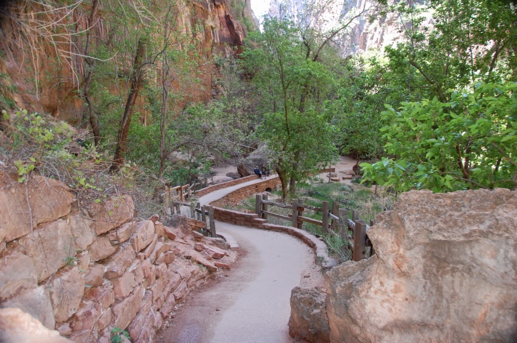
Riverside Walk at the Temple of Sinawava

We decided to take the shuttle bus from the main visitor's center to the eighth and final stop--the Temple at Sinawava. From this point, you can follow the Riverside Walk (2 miles r/t) which winds north up the increasingly narrow Zion Canyon...terminating at the entrance to the Zion Narrows. The Narrows is a slot canyon with sheer walls lining the Virgin River and is a popular upstream hike for those with good water shoes and a hiking staff. It takes about an hour to reach the most narrow sections, but NOT a good place to be if there is ANY risk of a flash flood!!!

Looking north up The Narrows
Climbers on the rock face

On our return shuttle, we stopped at the most scenic stops we had previously noted. Near Big Bend, we saw a couple rock climbers dangling from a sheer rock face. The 10-minute hike to Weeping Rock and Hanging Gardens takes you to a large bowl-shaped alcove where the lower layer of sandstone has eroded away. Water within the sandstone formations reaches an impermeable layer of rock and is forced out the side causing the "weeping" and irrigate a beautifully lush hanging garden with a little flowing stream below.

My intrepid Mom!
Mom & Art on the Weeping Walk Trail
Beautiful Zion Canyon

Our return to the main visitor's center signaled the end of our visit to Zion NP. After purchasing a couple souvenirs, we headed south towards St. George, UT and the local Wal-Mart to re-supply for the evening meal. After our stop at Wally World, it was time for my final exam: First time driving the RV! While Art & Mom washed down their Xanax with some whiskey, I settled into the driver's seat. Art had carefully chosen a nice desolate stretch of I-15 with light winds...piece of cake. However, within a few miles, road construction narrowed the roadway to a single twisting lane with jersey barriers on both sides for several miles. Although the driving was challenging, Mom only screamed once so I felt very fortunate!

Keeping it between the painted lines!

We exited I-15 at Route 169 and headed towards Echo Bay in the Lake Mead Recreational Area. Upon arrival at the RV park, we were met by the affable (and somewhat inebriated) "mayor" who welcomed us and led us to our campsite.

The "mayor" of the RV Park

As the sun began to set below the ridge of mountains, we began dinner preparations. During our shopping trip, Art had picked up a six-pack of Polygamy Porter. We sampled the brew and found it to be...enticing. However...we agreed that although one wife was plenty, MORE than one beer was necessary! And well-deserved on the final evening of our visit to the Utah Canyonlands.....


Tuesday, April 22, 2014

Kodachrome Basin and Zion National Park

Although the Kodachrome Basin campsite had full occupancy with firewood available, it was dead silent after 8pm--apparently this was not a partying crowd! Before breakfast, Art and I took a hike on the Angel's Palace Trail which allowed great aerial views of the entrance to and domain of Kodachrome Basin.

Only entrance into Kodachrome Basin
Entire area of Kodachrome Basin proper

The Angel's Palace Trail ascends a 150-foot high butte of soft brown rock eroded by wind & water into interesting contours like modeling clay. Looking about 20 miles west we could see the now-familiar hues of Bryce Canyon, while an interesting backbone arrangement of rock could be seen to the south.

Looking towards Bryce from Kodachrome Basin
Backbone of rock looking south from Kodachrome
White Navajo Sandstone with bands of iron oxide

There were hoodoos and a commonly-occurring erosion that Art thought looked like buffalo hide. Towards the end of our hike, we discovered that whoever diagrammed the "loops" into the Angel's Palace Trail map apparently used some artistic license as the only way out was to retrace our steps...or wander in circles forever.

Art's "Buffalo Hide"
Don't look, Mom...150 ft. straight down in all directions!

After breaking camp, we returned to Scenic Byway 12 and then headed south on Route 89 to Mount Carmel Junction. It was moderately windy, with the forecast predicting increasing winds.Art did a great job keeping our 30 foot "sail" between the proper lines on the road...crosswinds were particularly challenging!

"Too pooped to pump"

At Mount Carmel Junction, we headed west on the Zion-Mount Carmel Highway (Route 9) towards the entrance to Zion NP. At the NP gate we confirmed the procedure for oversize vehicles (like ours) to navigate the narrow 1.1 mile tunnel necessary to reach the center of Zion Canyon. Basically, you pay $15. to have the rangers stop 2-way traffic so that large vehicles can drive down the centerline of the road.

Our soon-to-be lunch spot looking at Checkerboard Mesa
Detail of Checkerboard Mesa

When traveling by RV, stopping for lunch can be quite interesting because you can literally "choose your scenery", then stop and fix lunch. We chose to stop at Checkerboard Mesa, whose horizontal lines are created by sedimentation and the vertical lines are caused by erosion...yielding an amazingly regular pattern.

Unique shale/sandstone with windswept look
Aussie Mustang Road Rally

After lunch, we continued along the Zion-Mount Carmel Highway encountering unique geology at every turn. And, of all things bizarre, an Australian Mustang Road Rally as well--those crazy Aussies! Finally we arrived at the 1.1 mile tunnel, which was completed in 1930 and was quite an engineering feat for its time.

Tunnel entrance
Tunnel history
Panoramic windows in tunnel
View out another tunnel window
End of the tunnel, at last!


Art did a masterful job driving down the centerline trying not to enlarge the tunnel with our RV! Every quarter mile or so there was a "window" that had been excavated by the tunnel builders to dump rock debris and bring in fresh air--managed to get a couple nice photos looking out those "windows".

Tunnel windows from below

After a series of hairpin turns (including a turnout that allowed us to see those "windows" from the outside), we entered the grandeur of Zion Canyon. Unlike Bryce Canyon, where you look DOWN into the Canyon, you look UP in Zion as you traverse the canyon floor. The mountains that make up the walls of Zion Canyon are truly majestic!

Our RV checking in at Zion NP entrance

We settled into our RV park (cable and Wi-Fi again!) about 5pm and were treated to an interesting drama at the adjacent campsite. An Asian couple and a late teens/20s daughter were trying to erect a tent in some fairly high wind amidst a fair amount of discussion. When the tent was finally up, the women were inside for nearly an hour while Dad chose to sit outside in a lawn chair in the clouds of blowing dust...and apparently just out of earshot of the discussion taking place in the tent. A little after 6pm, they took down the tent, packed up and headed...somewhere.