The Drawbridge Bistro is conveniently located between the Edgewater Inn and the Weathervane Restaurant, adjacent to the...you guessed it, the drawbridge! It is a small, upscale glassed-in breakfast nook with great harbor views. The early September buzz was that the DB was going to begin serving dinner next week in competition with the Weathervane Restaurant--although admittedly both share the same ownership.
 |
| Charlevoix Harbor |
 |
| View from our table at the Drawbridge Bistro |
 |
| Clang, clang, clang...the bridge goes up! |
 |
| Ferry arriving from Beaver Island (2 hrs/30 miles) |
Following a great breakfast, we continued north on Rt. 31 along Little Traverse Bay towards Petoskey--best known for the unique "Petoskey Stones". A Petoskey stone is a fossil, usually pebble-shaped, that is composed of fossilized rugose coral. These stones were formed as a result of glaciation, in which sheets of ice plucked stones from the bedrock, grinding off their rough edges and depositing them in the northwestern portion of Michigan's lower peninsula. Petoskey stones, the "State Stone" of Michigan, are fragments of a coral reef that was originally deposited during the Devonian period. When dry, the stone resembles ordinary limestone but when wet or polished using lapidary techniques, the distinctive mottled pattern of the six-sided coral fossils emerges. It is sometimes made into decorative objects. This link will take you to a wiki photo of a Petoskey stone:
http://en.m.wikipedia.org/wiki/File:Petoskey_stone_Hexagonaria_percarinata_2.jpg
Continuing north of Petoskey, we were anticipating our upcoming transition to Michigan's Upper Peninsula and the activities we had planned when these twin billboards suddenly appeared off Rt. 31...we will soon visit both!
 |
| Our upcoming boat cruise AND our Mackinaw Island hotel |
Earlier that morning, as we gathered together our belongings in Charlevoix, a local TV morning show was covering the annual Mackinaw Bridge Antique Tractor Crossing from Mackinaw City to St. Ignace. Nearly 1000 antique tractors were going to parade through Mackinaw City and then stream into the right lane of the Mackinaw Bridge. As traffic slowed on our approach to the Mackinaw Bridge, we realized we were going to be close witness to those tractors crossing the 5 mile long Mackinaw Bridge.
 |
| Tractors begin to stream onto the Mackinaw Bridge |
 |
| 1940 McCormick Farmall |
Kenny was driving...and I quickly learned that a simple wave and a smile to these tractor owners would get them waving and showing off their tractor--they were pumped up driving over this 200 foot tall bridge! Due to the lane restrictions, our bridge crossing took nearly 30 minutes longer than normal, but our timing could not have been better. Although the entire crossing would take the tractors nearly 4 hours, we reached the far end of the bridge just before the lead tractors arrived.
 |
| These Mackinaw Bridge towers are 500 feet tall |
 |
| Original 1976 Bicentennial paint job!!! |
As soon as we crossed the Mackinaw Bridge, we headed west on Rt. 2, providing wonderful scenic views of Lake Michigan as we drove along the rural southern coastline of the Upper Peninsula. We had definitely entered the "mom-and-pop, no big box zone" in northern Michigan...lots of small motels, restaurants selling pasties and homemade goods.
 |
| Our last views of Lake Michigan before heading towards Lake Superior |
 |
| Advertising the pasties one eats, NOT the kind one wears! |
Mid-afternoon we pulled into Sunset Motel in Munising, located on Lake Superior. This was a busy little motel with a great water views. Since our room was not quite ready and we wanted a short hike, we decided to visit nearby Munising Falls. We soon learned northern Michigan has dozens of waterfalls!
 |
| Fifty foot drop on Munising Falls |
 |
| A heated game of shuffleboard at the Sunset Motel |
 |
| Kenny enjoying a moment of relaxation by Lake Superior |
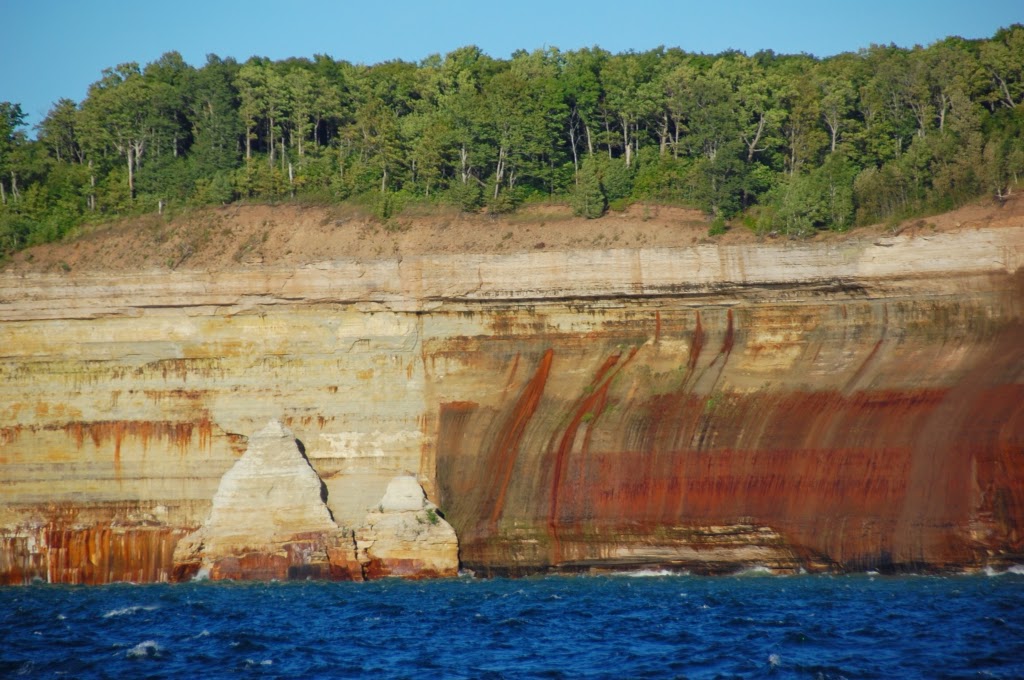
Munising is the western gateway to the 73,000 acre Pictured Rocks National Seashore, which hugs the Lake Superior shoreline for nearly 40 miles. Sandstone cliffs tower 50-200 feet above Lake Superior with multicolored layers of rock streaked with mineral deposits of ochre, tan, black and brown. The best way to view these cliffs is via Pictured Rocks Boat Cruises (authorized NPS concessionaire), which runs multiple daily boat tours from mid-May until mid-October.
 |
| NPS map of Pictured Rocks National Lakeshore |
 |
| Our trusty boat for the PRBC Sunset Cruise |
 |
| Water was a bit rough! |
We had arrived early in Munising to allow us to take the 5:45pm PRBC Sunset Cruise, with the sun slowly setting along these west-facing cliffs. Although the weather was clear, there was a gusty 15+ mph wind that would shorten our cruise to 2 hours due to 5-8 foot swells on Lake Superior.
 |
| Miner's Castle...note the overlook deck |
 |
| East Channel Lighthouse |
Departing the Munising dock, we ventured into Munising Bay towards Grand Island, passing close to the East Channel lighthouse. The scenery was gorgeous as we passed Miner's Castle and Painted Coves. Unfortunately, we were forced to turn back towards port as we began to encounter the large swells. We both agreed that we need to return to Munising for the full Sunset Cruise in the future.
 |
| Another waterfall....... |
On our return to port, we got a nice lake view perspective of our Sunset Motel. Seemed a perfect location for some carry-in dinner to enjoy the water views and imminent sunset. Unfortunately, Munising after Labor Day is a foodie nightmare. Hands down, the most popular place in town seemed to be "Dogpatch Legendary Vittles", but the menu sounded very...fried:(( After driving from one end of town to the other (2 minutes max!), we finally decided the local Subway would provide the best compromise for convenience and artery preservation.
 |
| Lake perspective of our Sunset Motel |
Arriving back at the Sunset Motel, we opened a bottle of wine and enjoyed our light dinner. And the promised sunset that evening did not dissapoint!!!


No comments:
Post a Comment